
Gilgit Baltistan
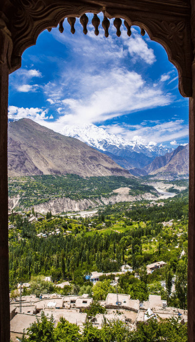
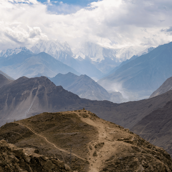
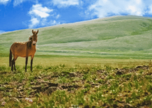
Gilgit Baltistan region has a total area of 72,496 sq. km with around 2 million population and lies at the extreme north of Pakistan. It is bordered by the China Republic on the north, India on the east, and Afghanistan and Central Asian states on the west. Gilgit Baltistan is the most amazing region due to its diverse natural beauty. Unique landscapes, evergreen forests, cold deserts, snow-capped mountains, and great cultural heritage are the attractions. It is a famous tourist place and has always been a paradise for mountaineers, trekkers and landscape loving people. One can experience cool weather over there throughout the year. It is surrounded by the highest peak in the world and is famous for trekking, climbing, rafting, camping, and paragliding.
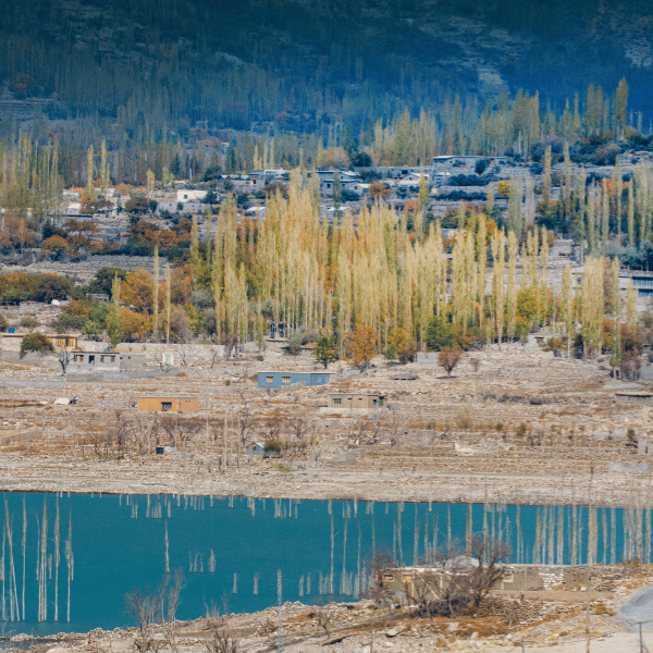
Gilgit is the capital city of the Gilgit-Baltistan region. It is situated in a valley formed by the confluence of the Indus river, the Hunza river, and the Gilgit river. Gilgit is a major tourist destination in northern Pakistan and is a hub for mountaineering expeditions within the Karakoram Range. It was a very important stop on the ancient Silk Road, and these days serves as a major junction along the Karakoram highway with road connections to China, Skardu, Chitral, and Islamabad.
Gilgit has a chilly climate. Weather in Gilgit is dominated by its geographical location, a valley in a very mountainous area, southwest of Karakoram Range. The summer season is temporary and hot. Because of this extremity in the weather, landslides are frequent in the area.
The best means of travel in Gilgit-Baltistan are Jeeps. Gilgit city is one of the two major hubs for all mountaineering expeditions in Gilgit-Baltistan. Most tourists headed for treks in the Karakoram or Himalaya Ranges depart from Gilgit
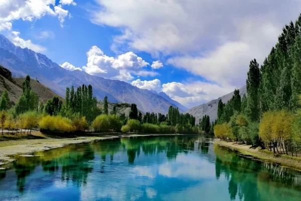
There are many tourist attractions near Gilgit: Naltar valley with Naltar Peak, Hunza valley, Nagar valley, Fairy hayfield in Raikot, Shigar town, Skardu valley, Haramosh valley in the Karakoram, Bagrot valley, Deosai park in Skardu, Astore valley, Phunder village, Ghizer valley, The Land of Lakes, and Yasin valley.
Culture and traditions in Gilgit Baltistan
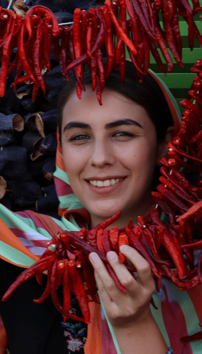
The cultural heritage of Gilgit Baltistan is rich, beautiful and unique and it exhibits local traditions, music, and local dress. The dress plays a central role in the identity of a person. Traditional clothing of the region is influenced by local culture, geography, and weather. The traditional cap of Gilgit Baltistan has played a major role to define the identity of people of Gilgit Baltistan. The cap has different names in the major local languages. In Shina and Khowar languages, the cap is called Khoi, in Burushaski, it is called Phartsun or Pharsen and in Wakhi it is called Sekeed. The design of the cap is slightly different in Baltistan and it is called Nating in Balti.
The traditional cap is a soft round woolen hat. It is made by a local artisan and is available in various colors. Whitecaps are most popular in the region and considered as part of a formal local dress. In many areas people especially, the older generation still wear their traditional cap all the time with pride. They consider it a sign of honor.
In many parts of Gilgit Baltistan, a small fresh flower is stuck in front and side of the cap. The flower is a symbol of freshness, fragrance, and livelihood. When the spring season starts sometimes the farmers and shepherds stuck a pine tree leave to symbolize life. One of the customs of many regions in Gilgit Baltistan is too stuck money into the cap while someone is dancing. This symbolizes the love and respect of the dancer from his friend’s relatives and fans. The dancer gives this money to the musicians once the dance is finished.
A variety of cultural festivals held in Gilgit Baltistan throughout the year present an exclusive side of its cultural diversity and different forms of expression. These festivals represent much important recurring merriment, cultural events and religious festival bring value additions to the surroundings. The folk music instruments commonly used in Gilgit Baltistan are Dadang (drum) Damal (percussion) Duff (a circle framed drum) Suranaye (a kind of flute) Ghajak (spiked fiddle) Sitar, Rubab, and Gabi (flute).
Most of the people in Gilgit Baltistan prefer to live in a joint family, which comprise anywhere between a group of two or more, even over 20 members sometimes. The commanding position in a family is held by the eldest earning male member. He consults other adult members on important issues, but it is his decision that ultimately prevails. However, a lot of importance is also given to the advice of the eldest members of the family.
It is the duty of a woman to take care of her home. As such, from her very childhood, a girl child is taught cooking, cleaning and dishwashing by her mother and other ladies in her family. The traditional arranged marriage has long been an integral part of the Gilgit Baltistan culture as against love marriage. It is the concept in which the parents and family members search for the prospective bride or groom, through their acquaintances or relatives.
LANGUAGES IN GILGIT BALTISTAN
Burushaski is spoken in Hunza Nagar, also in some parts of Gilgit, Ghizer and occupied Kashmir, India. The language is also spoken in Yasin valley with a slightly different accent. The people speaking Burushaski as mother tongue are known as Burushos/Hunzukuts.
Shina is the largest language spoken in all districts of Gilgit Baltistan, including all its variations. Shina is also spoken in some parts of Kargil and occupied Kashmir, India. The people speaking Shina as mother tongue are known as Sheens/Shinaki
Balti is spoken in Skardu, the largest area of Gilgit-Baltistan. The language, with various dialects, is written in the Tibetan script, reflecting historical ties to Tibet. This linguistic connection contributes to the rich cultural heritage of the highly populated and cultured Balti people.
TOURIST ATTRACTION IN GILGIT BALTISTAN
There’s so much to do in Gilgit Baltistan. No matter what time of year you visit, you will find there is never enough time to enjoy all the fun. Spring bursts forth with tree blossom, making it one of the best times to visit beautiful valleys, hill stations, and lakes. In summer, you can enjoy hiking, mountain biking, swimming or climbing. Autumn brings the falling of leaves from trees and the white of the birches in contrast with evergreen conifers. In winter you can enjoy snow activities like snowboarding or skiing. For every season in Gilgit Baltistan, there is plenty to see, lots to do, and everything to enjoy!
TOP DESTINATIONS IN HUNZA DISTRICT
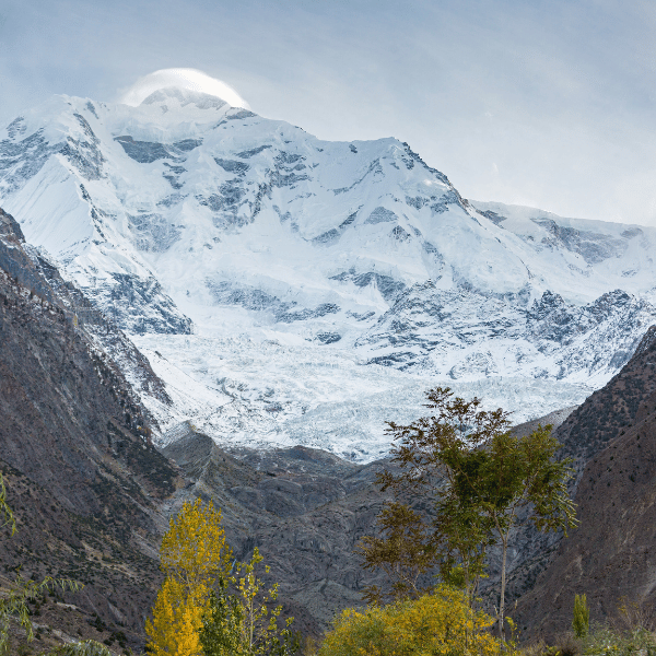
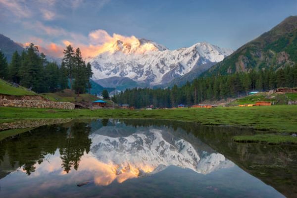
Rakaposhi Peak
Rakaposhi means shining wall. It is a part of the Karakoram Mountain Ranges and is 7,788 meters high. This mountain can be seen anywhere in Hunza. This mountain is surrounded by the following glaciers:
- Barpu
- Biro
- Bagrot
- Pisan
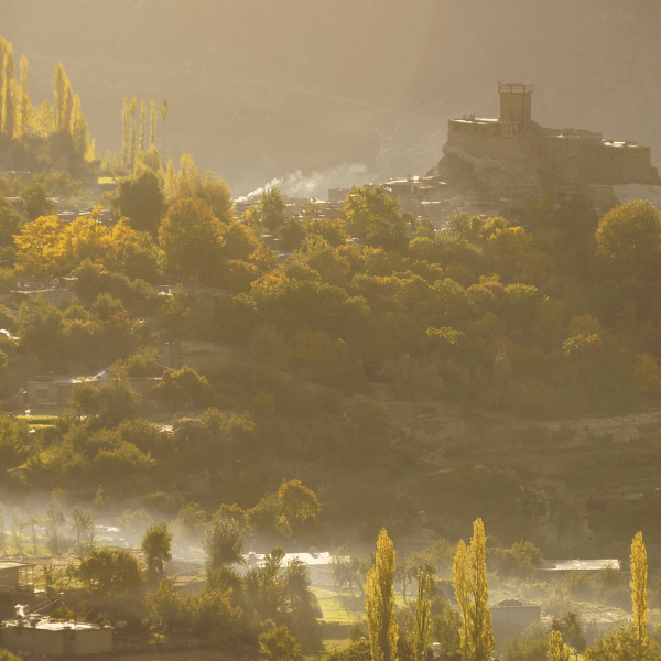
Karimabad
Karimabad, the capital of Hunza, boasts an ancient allure with its traditional houses and streets. As the residence of the Royal family, it preserves Hunza’s rich cultural heritage. Landmarks like Baltit Fort, Altit Fort, and the Queen Victoria Monument add historical depth, while the Hopper Glacier and trekking routes offer nature enthusiasts diverse experiences. The village is a treasure trove for food lovers with its traditional cuisine and a haven for shoppers seeking unique local handicrafts. Karimabad, nestled amidst the Karakoram Range, seamlessly intertwines history, culture, and natural wonders
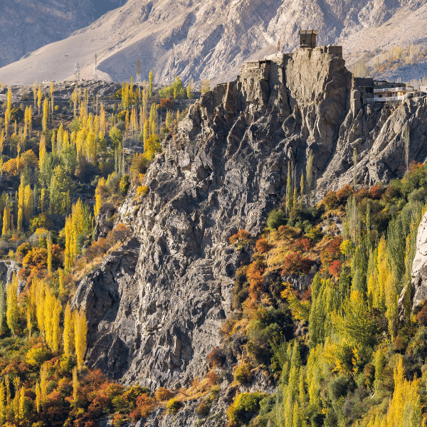
Altit Fort
Altit Fort is an ancient fort in the Hunza valley. It was home to the hereditary rulers of the Hunza state who took the title Mir. Altit Fort was the residence of a former prince around 1100 years old. This Fort was built in 6 different phases making the most of the various different levels of natural rock from the very high clifftop it is positioned on. This Fort is surrounded by the settlement of Altit Khun, once a bustling town for traders and caravans traveling along the Silk Route. The historic village forms an integral part of the core cultural enclave of Hunza.
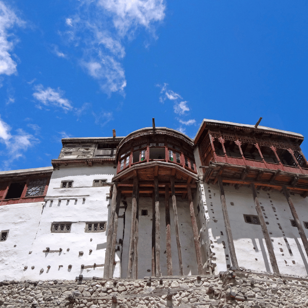
Baltit Fort
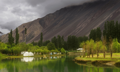
Baltit Fort is another fort in the Hunza valley, a must visited place in the valley. This Fort is 700 years old, but there have been rebuilds and alterations over the centuries. In the 16th century, the Mir (King) married a princess from Baltistan who brought master Balti craftsmen to renovate the building as part of her dowry. The architectural style is a clear indication of Tibetan influence in Baltistan at the time. Attabad Lake Attabad Lake is a lake in Gojal Valley, Hunza, Gilgit Baltistan, an administrative region of Pakistan. The lake was created in January 2010 because of the Attabad Disaster. Attabad Lake has become one of the biggest tourist attractions in Gilgit-Baltistan offering activities like boating, jet skiing, fishing, and other recreational activities.
Eagle Nest Duiker
If you are looking for the best place to view sunset and sunrise, Duikar village provides the best views anywhere in Pakistan. On a clear dark night, you can see once in a lifetime view of galaxies in the clear and pollution-free sky. it is a great photo-taking spot with a magnificent view of the whole Hunza Nagar district. Gulmit Village Anybody who wants to take the experience of looking at the best landscapes must-visit Gulmit. A walk through the valley exposes you to over 100 varieties of flora and fauna all of which are pervasive through this region. Passu Valley Passu lies between Batura & Passu Glaciers. The famous natural beauty of Passu is Tupopdan Peak; also known as “Passu Cones”, having picturesque shape is one of the most photographed peaks in the region.
Rush Lake
Another amazing lake in the Nagar Valley of Hunza is Rush Lake which is a great attraction for tourists. Sost Border Sost is the last village of a Hunza on Karakoram Highway next to the Chinese border. It is an important place on the highway for all passengers and cargo transports because all business is done through the Pakistan China border. Borith Lake Borit Lake is located in Gulmit valley. While exploring the beauty of Gulmit valley, you will encounter a saline lake of Borith. This lake is surrounded by vast plains. This lake 3is formed by the melted water of Ghulkin Glacier.
TOP DESTINATIONS IN GHIZER DISTRICT
Phandar Valley
TOP DESTINATIONS IN ASTORE DISTRICT
Minimarg River
A scenic beautiful valley close to the Indian border. Minimarg river flows through the valley and the area is covered with the grass slopes, thick pine forests, fertile fields, blue water streams, lush green grasslands, and tiny colorful flowers.
Rupal Valley
Rupal Valley is in the Astore District of Gilgit-Baltistan region of Pakistan. Rupal Valley is on the south side of Nanga Parbat, is accessed via the Astore Valley, which leaves the Karakoram Highway at Juglot 60km south of Gilgit.

Rama
Rama is a thickly forested valley with huge pine, cedar, fir and juniper trees. Rama lake is a peaceful and beautiful lake located near Rama village. The lake is one of the most beautiful tourist attractions in Gilgit Baltistan.

Sheosar Lake
Sheosar Lake means ‘Blind Lake’, as ‘Sheo’ in Shina Language means ‘Blind’ and ‘Sar’ means ‘Lake’. (Also called Sheosar Lake) is a lake situated in Deosai National Park The lake is at an elevation of 4,142 meters (13,589 ft.) in the Karakoram-West Tibetan Plateau alpine steppe.
TOP DESTINATIONS IN NAGAR DISTRICT

Rakaposhi
Rakaposhi is a mountain in the Karakoram mountain range in the Gilgit-Baltistan region of Pakistan It is situated in the middle of Nagar Valley, Nagar District, and the Danyore and Bagrote Valley approximately 100 km (62 mi) north of the capital city Gilgit of the semi-autonomous Gilgit-Baltistan region of Pakistan.

Chaprote
Chaprote, situated in the Hunza-Nagar District of Gilgit-Baltistan, stands as one of the earliest villages in the region. Chaprote, nestled in the breathtaking landscapes of Gilgit-Baltistan, combines natural beauty with a high literacy rate exceeding 80%, showcasing a unique blend of cultural richness and educational development.
THINGS TO DO IN GILGIT BALTISTAN
- Trekking
- Mountaineering
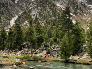
- Camping
- Paragliding
- Mountain Biking
- River Rafting
- Trophy Hunting
- Fish Angling
HUNZA DISCOVERY TOURS
+923555997098
Info@hunzadiscoverytours.com
hunzadiscoverytours@gmail.com
AUSTRALIA OFFICE
PO BOX 401, Moorabbin
VIC 3189 Melbourne Australia
info@snowleopardtours.com
+61 (3) 95031073
© 2025 Hunza Discovery Tours (Pvt) Ltd
Site Developed by